Tidal and Drift Corrections: A Field Procedure
Let's now consider an example of how we would apply this drift and tidal correction strategy to the acquisition of an exploration data set. Consider the small portion of a much larger gravity survey shown below. To apply the corrections, we must use the following procedure when acquiring our gravity observations:
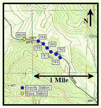
- Establish the location of one or more gravity base stations. The location of the base station for this particular survey is shown as the yellow circle. Because we will be making repeated gravity observations at the base station, its location should be easily accessible from the gravity stations comprising the survey. This location is identified, for this particular station, by station number 9625 (This number was choosen simply because the base station was located at a permanent survey marker with an elevation of 9625 feet).
- Establish the locations of the gravity stations appropriate for the particular survey. In this example, the location of the gravity stations are indicated by the blue circles. On the map, the locations are identified by a station number, in this case 158 through 163.
- Before starting to make gravity observations at the gravity stations, the survey is initiated by recording the relative gravity at the base station and the time at which the gravity is measured.
- We now proceed to move the gravimeter to the survey stations numbered 158 through 163. At each location we measure the relative gravity at the station and the time at which the reading is taken.
- After some time period, usually on the order of an hour, we return to the base station and remeasure the relative gravity at this location. Again, the time at which the observation is made is noted.
- If necessary, we then go back to the survey stations and continue making measurements, returning to the base station every hour.
- After recording the gravity at the last survey station, or at the end of the day, we return to the base station and make one final reading of the gravity.
The procedure described above is generally referred to as a looping procedure with one loop of the survey being bounded by two occupations of the base station. The looping procedure defined here is the simplest to implement in the field. More complex looping schemes are often employed, particularly when the survey, because of its large aerial extent, requires the use of multiple base stations.
Gravity
- Overviewpg 12
- -Temporal Based Variations-
- Instrument Driftpg 13
- Tidespg 14
- A Correction Strategy for Instrument Drift and Tidespg 15
- Tidal and Drift Corrections: A Field Procedurepg 16
- Tidal and Drift Corrections: Data Reductionpg 17
- -Spatial Based Variations-
- Latitude Dependent Changes in Gravitational Accelerationpg 18
- Correcting for Latitude Dependent Changespg 19
- Vari. in Gravitational Acceleration Due to Changes in Elevationpg 20
- Accounting for Elevation Vari.: The Free-Air Correctionpg 21
- Variations in Gravity Due to Excess Masspg 22
- Correcting for Excess Mass: The Bouguer Slab Correctionpg 23
- Vari. in Gravity Due to Nearby Topographypg 24
- Terrain Correctionspg 25
- Summary of Gravity Typespg 26