A Correction Strategy for Instrument Drift and Tides
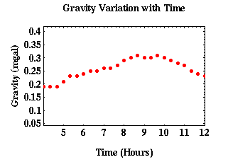
The result of the drift and the tidal portions of our gravity observations is that repeated observations at one location yield different values for the gravitational acceleration. The key to making effective corrections for these factors is to note that both alter the observed gravity field as slowly varying functions of time.
One possible way of accounting for the tidal component of the gravity field would be to establish a base station* near the survey area and to continuously monitor the gravity field at this location while other gravity observations are being collected in the survey area. This would result in a record of the time variation of the tidal components of the gravity field that could be used to correct the survey observations.
This procedure is rarely used for a number of reasons.
- It requires the use of two gravimeters. For many gravity surveys, this is economically infeasable.
- The use of two instruments requires the mobilization of two field crews, again adding to the cost of the survey.
- Most importantly, although this technique can be used to remove the tidal component, it will not remove instrument drift. Because two different instruments are being used, they will exhibit different drift characteristics. Thus, an additional drift correction would have to be performed. Since, as we will show below, this correction can also be used to eliminate earth tides, there is no reason to incur the extra costs associated with operating two instruments in the field.
Instead of continuously monitoring the gravity field at the base station, it is more common to periodically reoccupy (return to) the base station. This procedure has the advantage of requiring only one gravimeter to measure both the time variable component of the gravity field and the spatially variable component. Also, because a single gravimeter is used, corrections for tidal variations and instrument drift can be combined.
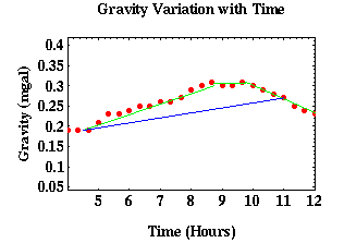
For example, assume that instead of using the green lines to estimate the tidal and drift components we could use the longer line segments shown in blue. Obviously, the blue line is a poor approximation to the time-varying components of the gravity field. If we were to use it, we would incorrectly account for the tidal and drift components of the field. Furthermore, because we only estimate these components intermittantly (that is, at the end points of the blue line) we would never know we had incorrectly accounted for these components.
*Base Station - A reference station that is used to establish additional stations in relation there to. Quantities under investigation have values at the base station that are known (or assumed to be known) accurately. Data from the base station may be used to normalize data from other stations.
Gravity
- Overviewpg 12
- -Temporal Based Variations-
- Instrument Driftpg 13
- Tidespg 14
- A Correction Strategy for Instrument Drift and Tidespg 15
- Tidal and Drift Corrections: A Field Procedurepg 16
- Tidal and Drift Corrections: Data Reductionpg 17
- -Spatial Based Variations-
- Latitude Dependent Changes in Gravitational Accelerationpg 18
- Correcting for Latitude Dependent Changespg 19
- Vari. in Gravitational Acceleration Due to Changes in Elevationpg 20
- Accounting for Elevation Vari.: The Free-Air Correctionpg 21
- Variations in Gravity Due to Excess Masspg 22
- Correcting for Excess Mass: The Bouguer Slab Correctionpg 23
- Vari. in Gravity Due to Nearby Topographypg 24
- Terrain Correctionspg 25
- Summary of Gravity Typespg 26