Tom Boyd's Introduction to Geophysical Exploration
This website was developed in the late 1990s by Dr. Thomas Boyd at Colorado School of Mines with support from the Society of Exploration Geophysicists. The website is a self-contained introductory course in calculus-based geophysics. Each section (Gravity, Magnetism, Resistivity, Refraction Seismology) contains a notes section that functions as the textbook for the class and a case-based set of exercises that illustrates the use of each geophysical technique. When Tom retired from teaching, Dr. Pamela Burnley at the Univeristy of Nevada Las Vegas acquired the materials from Tom and has been maintaining the site ever since. Over time this has required a certain amount of recoding, especailly for the applets. Updating is still in progress.
Variations in Earth's gravity field
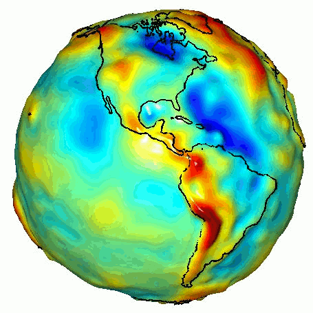
This animation was created with data from NASA's Gravity Recovery and Climate Experiment (GRACE). The colors represent gravity anomalies measured by GRACE. Red shows the areas where gravity is stronger than a simple 'idealized' value for Earth and blue reveals areas where gravity is weaker. This animation and more information about it can be found at NASA Jet Propulsion Lab's Photojournal website.
Each section of the course takes the student through the process of evaluating whether or not each geophysical technique will work for answering questions about the subsurface (e.g. presence of tunnels, depth to water table) in the same hypothetical housing development. Each section then guides the student through determining how to set up a survey and how to analyze the resulting data.