Request for Bid - Gravity
Bidding Scenario

Construction of a new housing development is planned on a 500m x 500m area in the foothills northwest of Golden, Colorado. A coal mine, the New White Ash Mine, operated on the site at the turn of the twentieth century. Before construction can begin, the site must be evaluated for the existence of old mine workings, particularly tunnels. Within the development, the subsurface geology consists of nearly vertically dipping, north-south striking members of the Pierre, Fox Hills, Laramie, Arapahoe, and Denver Formations. The coal being mined in the area originated in the base of the Laramie Formation and was between 3 and 5 meters thick.
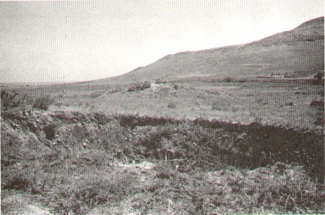
Although documented mine tunnels are relatively deep, bids are being sought for a single gravity profile to locate any undocumented, shallow, mine tunnels that could affect construction efforts. The contractor will be responsible for all aspects of survey design, fieldwork, processing, and interpretation. Shown to the left is a subsidence pit over the shaft of the Golden Star mine. Notice the relative freshness of the sides of pit suggesting recent subsidence. This image was taken from a consulting report done for Jefferson county entitled, "Coal and Clay Mine Hazard Study and Estimated Unmined Coal Resources, Jefferson County, Colorado" by A. R. Myers, R. A. Lindvall, J. L. Hynes, and J. B. Ivey, 1978.
From the mine records, existing mine tunnels would have the following characteristics:
- Tunnels are expected to be between 3 and 5m in diameter.
- Tunnels may be located anywhere between 5 and 100 meters in depth. Those located deeper than 15 meters, however, will not adversely affect subsequent construction efforts. If possible, however, the survey should be able to detect tunnels to as great a depth as possible.
- Owing to the geologic structure underlying the development, existing tunnels are expected to run in a north-south direction.
The client would like the survey to run along the exact middle of the area under consideration. In terms of the coordinate system established by the client, the gravity line should run from (-250,0) to (250,0). The area is relatively flat so that no elevation data or corrections are needed.
Your submitted bid should contain:
- A brief description of the problem,
- A brief discussion of survey design considerations,
-
A survey plan including:
- Gravity station interval along the single east-west line (in meters),
- Base station location along the line and the frequency at which you will reoccupy the base station,
- Number of gravity observations you will collect at each gravity station,
- A brief discussion of the survey design limitations and an estimate of the probability of success for this type of survey given the problem at hand,
- An appendix that contains a list of "if-then" statements that describes the physics of the problem under consideration. For example, if the tunnel is deeper, then the observed gravity anomaly would be smaller in amplitude and broader in shape,
- A break down of the survey costs and a total bid for the project. For this break down, note that the client will contract with a surveying company to establish the absolute locations of each of your gravity stations. You do not need to include the cost of location surveying in your bid.
Your bid should be composed in the format of a memo and be no longer than two type-written pages. Feel free, however, to include as many appendices as necessary. More information on the process of designing a gravity survey is given below.